


Centre constitutes ken betwa link project authority
What is the news:
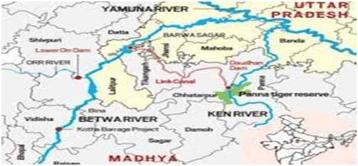
- The Centre constituted the Ken-Betwa Link Project Authority to implement the first initiative under the national river interlinking policy which seeks to bring nearly 11 lakh hectares of land under irrigation in the parched Bundelkhand region straddling Uttar Pradesh and Madhya Pradesh.
- According to a notification issued by the government on February 11, the Ken-Betwa Link Project Authority (KBLPA) shall be responsible for the execution of Daudhan dam, power house, tunnels and Ken-Betwa link water carrier.
About the committee :
- The Union government also constituted a 20-member steering committee, chaired by secretary, Department of Water Resources with secretaries of Department of Environment and Forests, Expenditure, Power and Tribal Affairs, among other members.\
- The steering committee will ensure compliance with provisions of the memorandum of agreement, approve fundamental administrative policies, byelaws and norms for KBLPA, decide on its proposals on obligations and loans besides approving and examining its annual budget, financial statements, the notification stated.
About KBLPA
- The KBLPA will be headed by a chief executive officer at the level of additional secretary to the Government of India and assisted by five additional CEOs at the level of joint secretary/chief engineer and one director finance.
- According to the notification, KBLPA will cease to exist after the completion of the project.
- The Ken-Betwa Link canal will be 221 km long, including a 2-km long tunnel.
- The project has two phases and four components. Phase-I will have one of the four components – Daudhan Dam complex and its subsidiary units such as low level tunnel, high level tunnel, Ken-Betwa Link canal and power houses. Phase-II will involve three components – Lower Orr Dam, Bina Complex Project and Kotha Barrage.
- The project is expected to provide annual irrigation of 10.62 lakh hectares, supply drinking water to about 62 lakh people, and generate 103 MW of hydropower and 27 MW of solar power, according to the Ministry of Jal Shakti.
Indian Rivers Inter-link project:
- The Indian Rivers Inter-linkis a proposed large-scale civil engineering project that aims to effectively manage water resources in India by linking Indian rivers by a network of reservoirs and canals to enhance irrigation and groundwater recharge, reduce persistent floods in some parts and water shortages in other parts of India.
- India accounts for 18% of the world population and about 4% of the world’s water resources.
- One of the solutions to solve the country’s water woes is to link rivers and lakes.
- The Inter-link project has been split into three parts: a northern Himalayan rivers inter-link component, a southern Peninsular component and starting 2005, an intrastate rivers linking component.
- The project is being managed by India’s National Water Development Agency Ministry of Jal Shakti. NWDA has studied and prepared reports on 14 inter-link projects for Himalayan component, 16 inter-link projects for Peninsular component and 37 intrastate river linking projects.
- The average rainfall in India is about 4,000 billion cubic metres, but most of India’s rainfall comes over a 4-month period – June through September. Furthermore, the rain across the very large nation is not uniform, the east and north gets most of the rain, while the west and south get less.
- India also sees years of excess monsoons and floods, followed by below average or late monsoons with droughts.
- This geographical and time variance in availability of natural water versus the year round demand for irrigation, drinking and industrial water creates a demand-supply gap, that has been worsening with India’s rising population.
The need:
1)Drought, floods and shortage of drinking water
- India receives about 4,000 cubic kilometers of rain annually, or about 1 million gallons of fresh water per person every year. However, the precipitation pattern in India varies dramatically across distance and over calendar months.
- Much of the precipitation in India, about 85%, is received during summer months through monsoons in the Himalayan catchments of the Ganges-Brahmaputra-Meghna (GBM) basin.The northeastern region of the country receives heavy precipitation, in comparison with the northwestern, western and southern parts.
- The uncertainty of start date of monsoons, sometimes marked by prolonged dry spells and fluctuations in seasonal and annual rainfall is a serious problem for the country.
- The nation sees cycles of drought years and flood years, with large parts of west and south experiencing more deficits and large variations, resulting in immense hardship particularly the poorest farmers and rural populations.
- Lack of irrigation water regionally leads to crop failures and farmer suicides. Despite abundant rains during July–September, some regions in other seasons see shortages of drinking water.
- Some years, the problem temporarily becomes too much rainfall, and weeks of havoc from floods.This excess-scarcity regional disparity and flood-drought cycles have created the need for water resources management. Rivers inter-linking is one proposal to address that need.
2) Population and food security
- Population increase in India is the other driver of need for river inter-linking. India’s population growth rate has been falling, but still continues to increase by about 10 to 15 million people every year.
- The resulting demand for food must be satisfied with higher yields and better crop security, both of which require adequate irrigation of about 140 million hectares of land.
- Currently, just a fraction of that land is irrigated, and most irrigation relies on monsoon. River inter-linking is claimed to be a possible means of assured and better irrigation for more farmers, and thus better food security for a growing population.In a tropical country like India with high evapotranspiration, food security can be achieved with water security which in turn is achieved with energy security to pump water to uplands from water surplus lower elevation river points up to sea level.
3) Salt export needs
- When sufficient salt export is not taking place from a river basin to the sea in an attempt to harness the river water fully, it leads to river basin closure, and the available water in downstream area of the river basin closer to the sea becomes saline and/ or alkaline water. Land irrigated with saline or alkaline water gradually turns in to saline or alkali soils.
- The water percolation in alkali soils is very poor leading to waterlogging problems. Proliferation of alkali soils would compel the farmers to cultivate rice or grasses only as the soil productivity is poor with other crops and tree plantations.
- Cotton is the preferred crop in saline soils compared to many other crops.Interlinking water surplus rivers with water deficit rivers is needed for the long term sustainable productivity of the river basins and for mitigating the anthropogenic influences on the rivers by allowing adequate salt export to the sea in the form of environmental flows.
4) Navigation
- India needs infrastructure for logistics and movement of freight. Using connected rivers as navigation is a cleaner, low carbon footprint form of transport infrastructure, particularly for ores and food grains.
5) Current reserves and loss in groundwater level
- India’s worsening water problem – satellite evidence of critical groundwater levels. The blue and purple regions have greatest levels of groundwater depletion. Courtesy – Goddard Space Flight Center, NASA, United States (2010).
- India currently stores only 30 days of rainfall, while developed nations strategically store 900 days worth of water demand in arid areas river basins and reservoirs.
- India’s dam reservoirs store only 200 cubic meters per person. India also relies excessively on groundwater, which accounts for over 50 percent of irrigated area with 20 million tube wells installed.
- About 15 percent of India’s food is being produced using rapidly depleting groundwater.


Leave a Reply